 ©1998 *Educational CyberPlayGround®
https://edu-cyberpg.com
Sign Up NetHappenings Blog News Headlines Email List
( ͡° ͜ʖ ͡°) sign up ©ECP NetHappenings Blog https://cyberplayground.org
Follow Twitter @CyberPlayGround
©1993 https://k12playground.com
© https://RichAsHell.com
SECURITY SECURITY SECURITY
TO ALL FRIENDS AND FAMILY IN FLORIDA JUST GO TO SHELTERS PLEASE.
Remember: when you lose power… when the generators lose power, when there is no more electricity to keep dead bodies cold it gets ugly.
What part of Florida will Milton hit? Full list of counties under evacuation orders. The entire Gulf Coast of Florida is especially vulnerable to storm surge.
This video shows the differences between a category 1, 2, 3, 4, & 5 hurricane in regard to potential home damage.
Know Your Evacuation Level in Sarasota
ARE YOU IN THE ZONE
FEMA Flood Zone Locator Application
Family in Zone A won’t evacuate
HURRICANE PARTY RIDE OUT THE STORM WITH MUSIC
One of Stevie Wonder’s 1st Concerts: The Epic 1963 Motortown Revue with Marvin Gaye & The Supremes! https://youtu.be/YOidjxPM6IY
The so called “free” Starlink service Muck graciously promised for communities devastated by Hurricane Helene is not actually free, you pay after 30 days according to those living in the aftermath – and the signup page.
 FACT: By the data, TWITTER = X = Elon Musk is currently running the largest far-right disinformation scheme in the history of the world. Not America—the world. Why?
Because Donald Trump has promised him unimaginable political power if he wins, and because Elon Musk wants to be a trillionaire.
Trump took ‘British naval secrets’ to Mar-a-Lago, says Christopher Steele
Elon Musk is running for shadow president.
Peter Thiel and Elon Musk are Vance’s patrons and the reason he’s on the ticket. Trump is old, in poor health, and doesn’t want to govern; he’s already promised Elon a big government role.
Musk and Thiel will rule openly via Vance.
Donald Trump says Jews have dual loyalties.
Elon Musk says Jews are importing hostile foreign hordes.
Tucker Carlson says Jews are funding white genocide.
Marjorie Taylor Greene says Jews cause natural disasters.
Fact check: No evidence for Trump’s claim he has been to Gaza
https://www.cnn.com/2024/10/08/politics/trump-gaza-fact-check/index.html
Kremlin refutes Trump denial on sending Putin COVID tests
These were rare COVID test machines, not the little test kits! -L
https://www.axios.com/2024/10/09/trump-putin-covid-testing-equipment-kremlin
Trump is a critic of China’s trade practices. His “God Bless the USA”
useless cheap useless bibles were printed there.
https://www.cbsnews.com/news/donald-trump-god-bless-the-usa-bibles-printed-in-china/
U.S. intel officials tell reporters that Moscow is “leveraging a wide range of influence actors in an effort to influence congressional races, particularly to encourage the U.S. public to oppose pro-Ukraine policies and politicians”

THE F’ing CHUZTPA
“I never expected people to get mad at me for handing Trump a get-out-of-jail free card for attempting a coup.” – John Roberts, basically. Like, the worst people in the world feigning ignorance for doing the maximum amount of damage possible to democracy.
CNN’s Joan Biskupic has new reporting that Roberts “was shaken” by the public outcry over his presidential immunity decision last term and the idea that he’d gotten tangled up again in Trumpian politics, despite his effort to emphasize that his ruling applied to all presidents. Roberts’ concern about his legacy could be important as the court stares down the possibility of hearing election-related cases this fall.
“In early 2024, the former president ordered an aide away from his office at Mar-a-Lago, his private club and residence in Florida, so he could conduct a private phone call with the Russian leader, according to Woodward’s account” –WAPO for those keeping score 2024 is THIS year.
 It’s going to happen. Let’s fucking go, y’all
https://www.michaelmoore.com/p/do-the-math-trump-is-toast
Do the Math: Trump Is Toast
If everyone does their part in the next few weeks, Trump is going down in flames. So say I.
 Clay Clark, who is organizing the meeting for faith leaders with Trump, says vaccines contain technology “that connects to 5G” and the Deep State is deploying thousands of satellites to connect to that technology “so they can know where you’re at at all times.”
 “The largest regulated water and wastewater utility company in the U.S. announced it was the victim of a cyberattack…
New Jersey-based American Water…provides services to more than 14 million people in 14 states and on 18 military installations…”
https://apnews.com/article/american-water-cyberattack-36423062dbce05c9aa70ef8aa07810cb
York County Pennsylvania state court judge hit with 31-count Federal indictment for corruption and obstruction of justice. Judges can go to prison. Easy peasy.
“The Trump admin protected Brett Kavanaugh from facing a full FBI investigation in the wake of serious allegations that he sexually assaulted two women…”during his controversial 2018 Senate confirmation to become a supreme court justice…”
Expert: Analysis shows Trump tax plan “taking money” from bottom 95% and “giving it” to richest 5%
Matthew Green @matthew_d_green
Apparently Florida TV stations that run ads supporting the abortion amendment are being threatened with prosecution by the government of Florida. We’re heading into a dark time in America for free speech. I hope everyone is prepared.
@matthew_d_green
Looks like Hungary will bring the CSAM reg (“chat control”) — a plan to mass-scan all private messages — back for another vote in the EU Council this Wednesday and Thursday. They’ve picked up support from Italy this time. I’m not joking when I say that this proposal has the potential to do major damage to European cybersecurity right at a moment when they’re going to need it most. See what’s happening in the US.
https://www.wsj.com/tech/cybersecurity/u-s-wiretap-systems-targeted-in-china-linked-hack-327fc63b
The way the European council has approached this feels increasingly anti-democratic. It keeps getting rejected for excellent reasons, they apply more pressure and come up with new justifications, then jam it back in. They clearly intend to pass it no matter what Europeans want.
All of the decentralized communication systems we build have benefited from the fact that, at least here in the US, we have a strong tradition of defending free speech (including software development.) That whole tradition goes up for a vote in about a month, and it may not win.

“I would say big tech right now is on the side of autocrats and dictators. It enables their rise. It breaks down our shared reality.”
– Nobel Peace Prize laureate Maria Ressa on Politico Tech
 Jack Mallers
Einstein discovered E=mc², he didn’t “invent” it.
Satoshi discovered #Bitcoin, he didn’t “invent” it.
No one controls #Bitcoin.
The identity of who discovered it is irrelevant.
Enough with the Satoshi speculation.
It’s dangerous, it’s disrespectful, and it’s fiat.
Trump has spoken with Vladimir Putin 7X since leaving the White House, per Bob Woodward.
‘That son of a bitch’: New Woodward book reveals candid behind-the-scenes conversations of Biden, Trump, Harris and Putin
Trump and Putin have had at least SEVEN one on one phone calls since Trump left the presidency.
Private citizens are forbidden under the federal Logan Act from engaging in foreign policy undercutting America.
So we have 7 new potential violations to investigate.
In his new book, legendary journalist Bob Woodward offers a remarkable look behind the scenes at President Joe Biden’s blunt, profanity-laced assessments and interactions with the world leaders who have shaped his presidency, from Benjamin Netanyahu to Vladimir Putin.
“That son of a bitch, Bibi Netanyahu, he’s a bad guy. He’s a bad fucking guy!” Biden declared privately about the Israeli prime minister to one of his associates in the spring of 2024 as Israel’s war in Gaza intensified, Woodward writes.
War is an intimate and sweeping account of one of the most tumultuous periods in presidential politics and American history.
War is an intimate and sweeping account of one of the most tumultuous periods in presidential politics and American history. Simon & Schuster
“That fucking Putin,” Biden said to advisers in the Oval Office not long after Russia’s invasion of Ukraine, according to Woodward. “Putin is evil. We are dealing with the epitome of evil.”
The book, “War,” also reveals new details about Donald Trump’s private conversations with Putin – and a secret shipment of Covid-19 testing equipment Trump sent to the Russian president for his personal use during the height of the pandemic.
NEW: A documentary about the Trump administration’s family separation policy will not air before Election Day because MSNBC is concerned about offending Trump, according to reports. MSNBC is officially garbage.
this is not financial advice
10/8/24 @dotkrueger https://x.com/dotkrueger/status/1843490883288609175
How much Bitcoin should you own?
Here’s my answer:
Age 20: 0.1 BTC
Age 35: 1 BTC
Age 50: 10 BTC
I think if you can hit these numbers, you will be good.
For 20 year olds, you need to do whatever you can to get that first 10 Million Sats. Not easy, but doable.
For 35 year olds, you need 1 BTC more than you need that fancy car, or downpayment. In 20 years, that could be worth 10 Million. That’s your retirement.
For 50 year olds, 10 BTC should be enough to retire on in 10 years, selling some or borrowing against it.
Anonymous
Collectively, Anonymous has always been against cult like fascist movements such as MAGA, Qanon etc.
So, when you see “Anons” promoting Trump or MAGA – it’s most likely someone trying to co-opt the idea of Anonymous. Anonymous’ ideology and MAGA’s ideology are incompatible.
Anonymous is Anti MAGA therefore
we’re anti-fascist
we’re anti-violence
we’re anti-racist
we’re against ignorance
we’re against injustice
we’re with the people
▓▓▓—▓▓▓—▓▓▓—▓▓▓—▓▓▓—▓▓▓

 ❤️️ Sign Up ©2025 NetHappenings News Email List https://cyberplayground.org
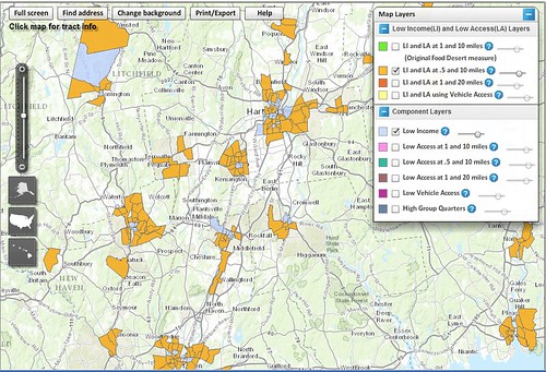 Users of ERS’s Food Access Research Atlas can opt to view low-income census tracts (shaded in gold and in light blue) in a selected area of the country. The gold-shading indicates low-income tracts where a substantial number or portion of residents live at least 0.5 mile from a supermarket in urban areas or at least 10 miles in rural areas. (Central Connecticut)